


Tour du pays d'Allevard - ét.5

cron
User
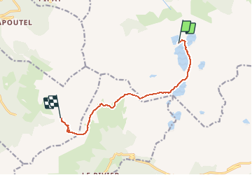

Length
9.5 km

Max alt
2575 m

Uphill gradient
532 m
Km-Effort
17.9 km

Min alt
1726 m

Downhill gradient
924 m
Boucle
No
Creation date :
2019-08-05 14:27:51.206
Updated on :
2019-08-05 14:28:27.409
3h22
Difficulty : Difficult

FREE GPS app for hiking
 SityTrail
IGN / Geographical institutes
SityTrail Plus
The world is yours!
About
Trail Walking of 9.5 km to be discovered at Auvergne-Rhône-Alpes, Isère, Le Haut-Bréda. This trail is proposed by cron.
Positioning
Country:
France
Region :
Auvergne-Rhône-Alpes
Department/Province :
Isère
Municipality :
Le Haut-Bréda
Location:
La Ferrière
Start:(Dec)
Start:(UTM)
270769 ; 5014804 (32T) N.
Comments